Status Report March 2001
This project was already announced on the meeting of the ICES Working Group on Marine Data Management in April 2000 in Hamburg and to the ICES Baltic Committee Meeting in September 2000. We would like to inform the HELCOM MONAS about this project and ask for collaboration and cooperation.
The BALTIC project is still in the phase of conception and open for proposals and intentions of participation. We will keep interested parties informed about the progress of our activities on our website. Please send suggestions and comments to sabine.feistel@io-warnemuende.de.
With the target to support e.g. climate-related investigations, interdisciplinary studies, numerical modelling and permanent monitoring, we intend to develop an encyclopaedic "climate atlas" for the Baltic Sea, similar to the famous Levitus global oceanographic data set, and going far beyond the already existing data collections of Bock/Lenz (1971) and Janssen/Backhaus/Schrum (1999).
In the recent years a lot of historical CTD and bottle data have been reconstructed in the HDR (historical data rescue) framework of the marine research institutes around the Baltic. Beginning with the data already available in the databanks of IOW, BSH and ICES we plan to build a collection of virtually all accessible data of the Baltic Sea. In a preceding study, we found out that we could include much more data than presently available at ICES.
In a first stage the atlas is based on oceanographic temperature/salinity/pressure measurements with higher vertical and time resolution and quantities immediately derived thereof e.g. density, sound speed, entropy, enthalpy, thermocline depth, halocline depth. In the next stage of development data like nutrients, pollution, alkalinity etc should be added. Later the atlas is to include accompanying information like topographical and shoreline data, GHCN (Global Historic Climate Network) data, PSMSL (Permanent Service of Mean Sea Level) data, river discharge data, and ice coverage data.
Our aim is to collect physical and chemical quantities as well as meteorological, economic and historical background quantities to unify, analyse and condense them. A variety of calculations like horizontal distributions on selected depths, at the surface, on the bottom, gridded monthly means, or time series at selected positions are planned. Finally we want to provide a comprehensive, processed numerical dataset on CD for interdisciplinary research projects in the Baltic region. A catalog of graphs and diagrams shall illustrate the results.
Inventory of currently available data
At IOW, e.g., data are available which are in the ICES data bank not yet. They are under reconstruction in the historical data rescue framework. Certainly, similar data exist at other Baltic institutes which may be used for this intended data collection.
| Number of expeditions totally (1950-1999) : 460 | |||
| thereof | H/C | CTD | Current |
| 369 | 264 | 190 | |
| doubtful | 56 | 10 | 144 |
| "East Edge" (Norway) 25 (to be inspected) | |||
| H/C |
Hydro/Chemical Bottle Data in standard bottle depths mainly in Baltic Proper from 1950-2000 (depth, temperature, salinity, dissolved oxygen, hydrogen sulphide (H2S-S), nitrate (NO3-N) content, nitrite (NO2-N) content, phosphate (PO4-P) content, ammonium (NH4-N) content, silicate (SIO4-SI) content, total phosphorous (P) content, total nitrogen (N) content) |
| CTD |
Bathysonde Data in 1m steps mainly in Baltic Proper from 1976-2000 (conductivity, temperature, oxygen, pressure) |
| Current | Mechanical Current Measurements mainly at Darss Sill from 1973-1992 |
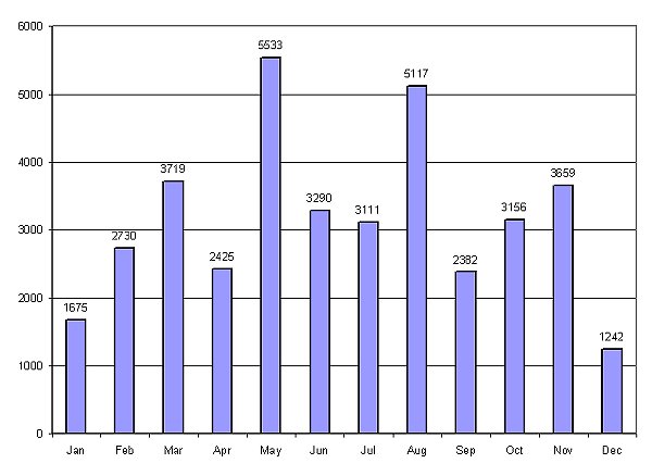
Number of stations/month from 1950-1999

