Data product Baltic Thalweg (Level 4)
(Version 0.3, 22.09.2017, V. Mohrholz)
Description
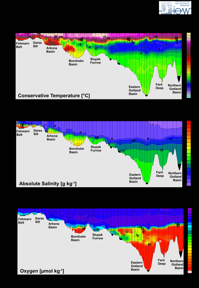
The data set consists of CTD data of pressure, in-situ temperature, conservative temperature, absolute salinity and dissolved oxygen concentration along the Baltic thalweg transect. It starts in the Kiel Bight at 54°39.6’N, 10°45.6’E and follows the Baltic valley line to 58°58.4’N, 20°12.9’E in the northern Gotland Basin. The total length of the transect is 552 nautical miles (1022km). The data set is derived from validated in-situ measurements with a SeaBird CTD 911 system. The field data were gathered in frame of the IOW long term observation program in the central Baltic and the Baltic monitoring program (western Baltic), funded by the BSH. The field data were interpolated on an equidistant depth vector with 1m depth steps. The parameters conservative temperature and absolute salinity were calculated using the TEOS10 toolbox. The data set covers the ten year period from 2014 to 2019 with 5 grids per year, usually for February, March, May, July and November.
Available time range: November 2014 - August 2019
Structure of NetCDF file:
Global Attributes
| Name | Content |
| title | Hydrographic data set of Baltic thalweg transect (CTD data at stations) |
| version | Version number of data product, date of data processing |
| subtitle | Cruise description string (e.g. used for figure captions) |
| datasetID | Internal cruise identifier (e.g. ‘btw2016_03’) |
| cruiseID | Offical cruise number, (e.g. ‘EMB124’) |
| reference | Data reference for citation of data product |
| publisher | Leibniz Institute for Baltic Sea Research (IOW) |
| rights | Level 3 data, only for internal use |
| creator | Name of operator |
| contact | Email address for information and support |
| description | Data set description text |
Dimensions
| Name | Axis | Long name | Unit | Description |
| depth | Z | Depth | m | Depth below surface, positive downward |
| time | T | Time | days | Time of CTD station |
| cruise | C | Cruise ID | none | Cruise identifier (e.g. '201603') |
Variables
| Name | Axis | Long name | Unit | Description |
| latitude | T-C | Latitude | deg N | Latitude of CTD profile |
| longitude | T-C | Longitude | deg E | Longitude of CTD profile |
| stat_dist | T-C | Station distance | km | Distance along the thalweg transect allocated to CTD station |
| bottom | T-C | Bottom depth | m | Bottom depth from echo sounder |
| Press | T-C | Pressure | dBar | Pressure value data |
| Temp | T-Z-C | in-situ Temperature | °C | in-sito Temperature data |
| CTemp | T-Z-C | Conservative temperature | °C | Conservative temperature data |
| ASal | T-Z-C | Absolute salinity | g/kg | Absolute salinity data |
| Oxy | T-Z-C | Dissolved Oxygen | μmol/kg | Dissolved Oxygen data |
| stat | T-C | Station | none | Station ID of particular cruise |
| stat_dmin | T-C | Data profile start depth | m | Data profile start depth of CTD station (positive down) |
| stat_dmax | T-C | Data profile end depth | m | Data profile end depth of CTD station (positive down) |
Metadata
| Creator: | Mohrholz, Volker |
| Titel: | Gridded hydrographic data set of Baltic thalweg transect 2014-2019 |
| Publisher: | Leibniz Institute for Baltic Sea Research (IOW) |
| PublicationYear: | 2016 |
| Updated | 2019 |
| Rights: | CC BY-NC-ND 4.0 International |