
Digital Topography of the Baltic Sea
A high resolution spherical grid topography of the Baltic Sea
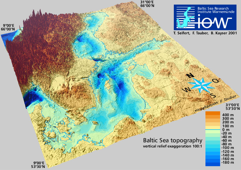
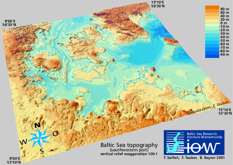
The data sets presented here provide a digitised topography of the Baltic Sea. Land heights and water depths have been calculated for two regular spherical grids from available data. Data set "iowtopo2" covers the whole Baltic Sea from 9° to 31° East and from 53°30’ to 66° North by (660 x 750) grid cells, see Fig. 1. The resolution is 2 minutes with respect to longitude, and 1 minute to latitude. This is approximately 1 nautical mile, or 2 km resp. The region of the Belt Sea from 9° to 15°10’ East and from 53°30’ to 56°30’ North, see Fig 2, is comprised within data set "iowtopo1" with a twofold higher resolution (1 minute in longitude and 0.5 minutes in latitude corresponding to approx. 1 km). The data sets were published at the Baltic Sea Science Congress in Stockholm on 27. November 2001 as poster 147. A short description of the data compilation has been published on-line.
The data specify a representative average of the water depth or the land height of each grid cell, counted by negative and positive values in meters. Some statistical parameters allow a rough estimate of the reliability of the data. (Please be aware that data are rather uncertain in regions where strong gradients of the bottom relief occur, esp. the northern parts of the Baltic. There is an urgent need of further bathymetry data to become available for the Baltic beyond 59° North.) Since a common average of land heights and water depths lead to rather unsatisfying results with respect to the gridded shoreline, a landmask is proposed in both data sets. The landmasks were derived from the global high resolution shorelines GSHHS and RANGS, and used to get a "naturally looking" composite topography (z_topo see below).
Data are provided in two formats. NetCDF files (*.nc) are self-desribing binaries which may be visualised and processed by tools like Ferret, Grads or Matlab. Alternatively rather big ascii files (*.dat) are given which start with two header lines and contain the following data:
< 0: number of neighbors interpolated to fill this empty cell
< 0: number of iterations to find direct neighbours for interpolation
Updates
- 1. Update from 01.05.2002
- Addendum 19.07.2002
- 2. Update from 31.01.2003
- 3. Update from 30.05.2007
- 4. Update from 16.01.2008
If you would like to be informed about further revisions please join the mailing list.
Download
Windows (packed by pkzip):
ASCII: iowtopo.dat.zip (10 MB)
NetCDF: iowtopo.nc.zip (8 MB)
Matlab: iowtopo.mat.zip (9 MB)
UNIX/LINUX (packed by tar and gzip):
ASCII: iowtopo.dat.tgz (10 MB)
NetCDF: iowtopo.nc.tgz (8 MB)
Matlab: iowtopo.mat.tgz (9 MB)
Reference
The application of the data has to be cited as scientific work by: T. Seifert, F. Tauber, B. Kayser: 2001: "A high resolution spherical grid topography of the Baltic Sea – 2nd edition", Baltic Sea Science Congress, Stockholm 25-29. November 2001, Poster #147, www.io-warnemuende.de/iowtopo. Any contribution to a further improvement of the data is welcome, please contact torsten.seifert@io-warnemuende.de
Application of data and disclaimer of warranty
These data sets are a piece of scientific work which relies on free interchange of scientific data. Therefore the data are available for scientific research. The data must not be used for navigation.

This work is licensed under a Creative Commons Attribution- 4.0 International License.
1. Update from 01.05.2002
The data set iowtopo2 now also includes the data resampled by Seifert & Kayser (1995) from sea charts. Thus a complete coverage of the full Baltic Sea is achieved (there were empty cells in z_water using only the DYNOCS bathymetry). Moreover, the updated bathymetry looks smoother and shows smaller location errors (for instance at Landsort Deep), see the description of data resampling. Within the Baltic Sea the new water depth show in the average changes of ± 0.5 m, but deviations up to ± 70 m occur at strong bottom gradients, see the difference figure. In Skagerrak (9-12°E, 57-60°N) the maximum differences are - 157 m and + 96 m.
Finally, data north off Norway (longitude < 13°E, latitude > 63°N) have been blanked out by the land mask. This region is out of our focus. Moreover, the available DYNOCS data are obviously deteriorated there. A frequency histogram shows that depth of 200 m, 300 m and 400 m are over-abundant. Thanks to Frank Janssen for giving the hint.
Addendum 19.07.2002
Seppo Kaitala (FIMR, Finland) asked for georeference of iowtopo data:
We have not taken reference to any special earth ellipsoid. All the data used were considered to refer to geographical longitudes and latitudes in decimal degrees. Mean values for each grid cell were sampled by allocating data matching the region covered by the corresponding grid cell (with a small overlap).
IOW data were sampled mainly from German sea charts referring to WGS84 and mean sea level. The Swedish-Lithuanian GEOBALT chart also refers to WGS84. Danish data usually are given in UTM32 based on ED50. To our knowledge horizontal deviation between these reference systems are some 100 m at maximum. This might be neglected for a grid spacing of approx. 1 km within Belt Sea, and 2 km within Baltic.
With respect to the water depth the possible error is not exactly known. The MESODYN data are averaged over some independent measurements thus referring to an approximate mean sea level. Vertical reference of the other data sets is not known. I think Danish data and GEOBALT also refer to a certain mean. In any case since water depth are measured downwards from the surface of the sea the vertical uncertainty should be much less than the height differences of some 10 m between the datum in different reference systems.
Data statistics given in iowtopo1 shows that within Belt Sea data sets were in good agreement differing by -/+ 1 m in average. (This confirms the assumption that the mean sea level of data sets must be nearly the same.)
The large deviations in depth found within the Baltic Proper are mainly subject to strong bottom gradients. But there are also obvious location errors (or differences) in data which might be improved. This depends on input of data and better experience. We are open to join any scientific cooperation aiming on a reliable digitised bathymetry of the whole Baltic Sea.
2. Update from 31.01.2003
All output data in netCDF and ascii files are rounded equally to 0.1 m now. Further changes as described in 1. update. By a mistake downloadable data were not updated in May 2001.
3. Update from 30.05.2007
In file iowtopo2_rev03 the depths z_topo and z_water have been changed in the area of the eastern Gotland Sea (18°30'-21°30'E, 56°30'-58°N) to avoid an artifitial steep bottom gradient at the north-eastern rim of the basin (only data from the GEOBALT chart, Gelumbauskaite et al. (1999), and from the MESODYN measurements, Reissmann (1999), are included in this area now). From now on the release is indicated in the file names (rev03 for current, rev02 for last version).
4. Update 16.01.2008
By an error in the output filter wrongly formatted ascii data were provided
for iowtopo2_rev03.dat.
This has been corrected by setting undefined z_water and z_land to zero.
Note that the landmask is land=1 and water=0 since rev03.