Application of satellite data to Baltic Sea
Development of cyanobacteria in the Baltic Sea
The cyanobacteria development is a regular process, which takes place every summer. Different is the spatio-temporal evolution, which can be detected only by means of satellite data of water color. The IOW uses this data for the study of river discharge and the phytoplankton blooms in different regions of the world ocean. Data of the Moderate Resolution Imaging Spectroradiometer (MODIS) operating at the American satellites Terra and Aqua were also included for monitoring of cyanobacterial blooms in the Baltic Sea until autumn 2018. Flakes of cyanobacteria in the surface waters and accumulations on the surface massively change the water color. The information on the spreading of cyanobacteria in the western Baltic were delivered daily during the summer months to the institutions that are responsible for the use of the German Baltic Sea coast: State Office for the Environment, Nature Conservation and Geology (LUNG); State Office of Health and Welfare (LAGUS); Schleswig-Holstein State Department of Agriculture, Environment and Rural Areas (LLUR); Tourism MV.
Detailed information on cyanobacteria see also:
Satellite view of algae bloom
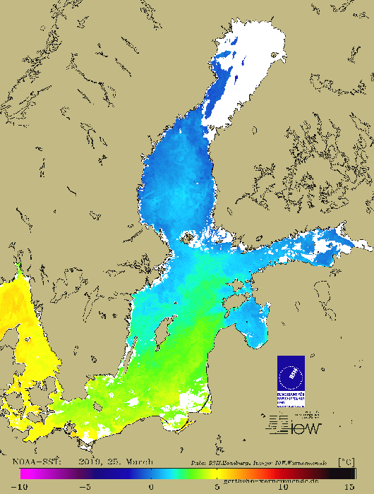
Sea Surface Temperature of the Baltic Sea
Sea Surface Temperature is a key parameter for oceanographic and atmospheric investigations because it is in direct relationship to heat, impulse and gas exchange in the ocean. The Advanced Very High Resoltuion Radiometer (AVHRR) on NOAA (National Oceanic and Atmospheric Administration) -weather satellites measures the water sea surface temperature in the thermal infrared spectral region of the electromagnetic spectrum. The Federal Maritime and Hydrographic Agency (BSH) in Hamburg operates a receiving station and collects NOAA-AVHRR data for the North and Baltic Sea. After data processing, calculated SST as grey scale values are provided to IOW for application in Baltic Sea research. The remote sensing group generates colorized SST-maps for the Baltic Sea.
Main topics of SSTapplications in Baltic Sea research are support of monitoring program, investigation of dynamical processes and coastal discharge, and climatologic analyses.
Satellite image of the month
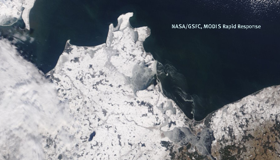
Ice observation
Satellite data allow the observation of ice development at sea. For the operators of our MARNET stations in the western Baltic Sea we pursue the ice development, in order to be able to take in time safeguards.
Image credits: NASA/GSFC, Rapid Response
Satellite image Ice conditions