
Dr. Inken Schulze
Seestrasse 15
D-18119 Rostock
Germany
Expertise
Hydroacoustics • Marine Geophysics • Marine Habitat Mapping
I’m a marine geophysicist investigating the impact of different benthic habitats and anthropogenic physical pressures at the seafloor on hydroacoustic signals. My research focus hereby is on multifrequent backscatter to improve marine habitat mapping. I have experience in collection, processing and interpretation of hydroacoustic and sub-bottom profiler, and seismic data.
Anchor Tracks at the Seafloor
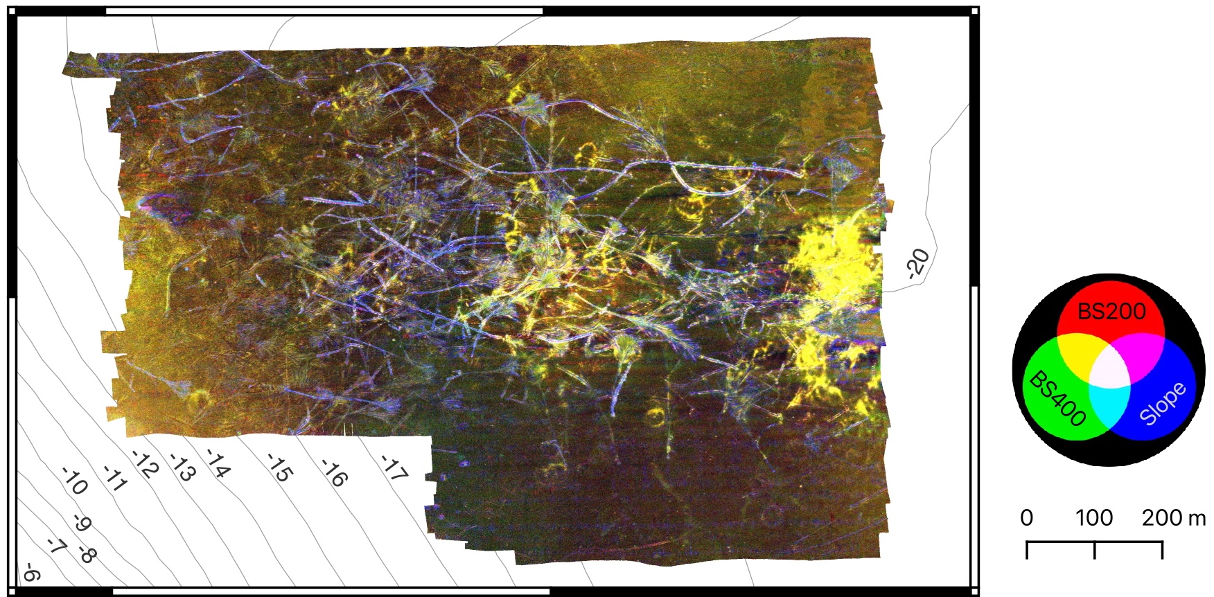
High-resolution multibeam data reveal a dense network of anchor marks on the seafloor of the Eckernförde Bay – deep furrows, raised sediment mounds, and extensive abrasion zones caused by anchor chains. Analysis of changes over several years shows that while these structures gradually flatten, they remain detectable in the sediment and in hydroacoustic data over the long term. Approximately 20% of the surveyed area was directly impacted. The results demonstrate that anchoring has a lasting effect on seafloor integrity and highlight the urgent need for spatial management strategies (Schulze et al., 2025).
Multifrequency Backscatter Mapping

This study investigated the seasonality of acoustic backscatter intensities, exploring three habitats in the southwestern Baltic Sea: 1) a mussel-covered reef, 2) coarse sand and gravel (CSG), and 3) seagrass meadows.
The multifrequency and multiseasonal backscatter maps distinguish the three habitats and reveal variable seasonal differences in acoustic backscatter. The use of multiple frequencies is beneficial as the low frequency is sensitive to changes in the shallow subsurface and benthic features such as seagrass rhizomes, while the higher frequency highlights changes related to coarser sediment (Schulze et al., 2022).
3D seismic lander system OWUHRSE

The newly developed 3D seismic system operates three transducers (130 kHz) from a stationary lander and allows non-destructive imaging of small-scale objects within the top decimeters of silty sediments, covering a surface area of 0.2 m2.
In laboratory experiments, samples such as shells, stones, and gummy worms of varied sizes (down to approx. 1 cm diameter) could be located in the 3D seismic cube to a depth of more than 20 cm and differentiated by a reflected amplitude intensity and spatial orientation. In addition, simulated bioturbation structures could be imaged. In a practical application, the system allows to determine the abundance of endobenthos and its dynamic in muddy deposits in-situ and thus identify the intensity of local bioturbation (Schulze et al., 2021).
